Crash Investigation Tools
Discover the tools used for crash investigation
11 Crash Investigation Tools

Mechanical Measurement Tools
Mechanical measurement tools are a traditional and widely used method for documenting traffic crash scenes. They can provide reliable measurements when used correctly but are slower, more labor-intensive, and less efficient than modern digital alternatives.
Interior observation forms
Advantages
Disadvantages
Equipment is inexpensive, widely available, and easy to deploy
Requires personnel to spend more time exposed to live traffic while taking measurements
Basic crash scene documentation can be performed after relatively short training
Manual measurement and recording increase the likelihood of human error
Can produce accurate results when used by properly trained investigators
Data collection is slow and can be challenging on curved roads or areas with significant elevation changes
Photogrammetry
Photogrammetry is a crash scene documentation method that uses multiple photographs to create accurate 3D measurements and scaled diagrams through specialised software. It can reduce time spent at the crash scene and improve roadway clearance, but it requires skilled post-processing and is dependent on image quality, visibility, and weather conditions.
Advantages
Disadvantages
Photographs can be collected quickly, reducing the time investigators spend at the crash scene
Accurate processing and interpretation of photographs require trained and proficient investigators
Digital cameras are readily available and less specialized than many other surveying tools
Evidence must be clearly visible, and adverse weather conditions can affect data quality
Creates detailed 3D datasets that can be exported to CAD software for scaled crash scene diagrams
Although fieldwork is faster, office-based processing and reconstruction can be time-consuming

Exterior car photo angles (left) and a set of photographs for photogrammertry (right)
LiDAR (Light Detection and Ranging)
This is an advanced remote sensing technology that uses laser measurements to create highly accurate maps and measurements of traffic crash scenes. LiDAR is routinely used by law enforcement as a speed measuring tool, but for traffic crash reconstruction, it is used to measure distance rather than speed.
Advantages
Disadvantages
Produces precise measurements and detailed scene documentation suitable for reconstruction and reporting
Rain and other adverse weather conditions can reduce the effective range and performance of the system
Allows measurements to be taken from a distance, reducing personnel exposure to live traffic
Digital outputs can be easily integrated into compatible software for analysis, reporting, and information exchange
Requires specialized equipment and can be time-consuming to deploy and operate, particularly in reflectorless mode
Electronic Total Station (ETS)
This a surveying technology used in crash reconstruction to create highly accurate scaled maps by combining angle and distance measurements. ETS comprises four components: the theodolite, the Electronic Distance Measurement Instrument (EDM), an optical prism, and a data collector.
The theodolite measures horizontal and vertical angles between points, while the EDM measures the slope distance between points. The reflected light from an optical prism is used to capture distance and angles from the theodolite, and this data is combined with graphic attributes recognised by the software to generate an accurate scale map of the scene.
Advantages
Disadvantages
Produces detailed and reliable measurements for crash scene mapping and reconstruction
Once set up, measurements can be collected faster and with greater accuracy than tape or wheel-based methods
Collected data can be easily stored, transferred, and integrated into mapping and reconstruction software
Measurements require positioning a prism directly over evidence, increasing exposure to traffic hazards
Data quality and collection speed can vary based on the experience and expertise of the user
The Reflectorless Electronic Total Station
An advanced version of the traditional ETS, it can measure distances without requiring a prism at every point, improving both safety and efficiency. It provides highly accurate crash scene documentation while reducing investigators' exposure to traffic and accelerating scene clearance.
Advantages
Reflectorless measurements reduce the need for personnel to enter traffic lanes or stand directly over evidence points
Disadvantages
More advanced technology and specialized components increase acquisition and maintenance costs
Faster data collection and reduced on-scene investigation time support quicker roadway clearance
Produces precise measurements and digital outputs that can be easily shared and integrated into reconstruction software
Effective use relies on specialized software, proper equipment setup, and operator expertise
Global Positioning System (GPS) and Global Navigation Satellite Systems (GNSS)
These systems are widely used in crash reconstruction to provide highly accurate location and mapping data. They consist of two units: a rover and a base, which communicate with each other using a Class II Bluetooth connection. The use of GPS Systems for crash reconstruction has become more affordable.
Advantages
Disadvantages
Reduces on-scene investigation time and supports quicker roadway clearance
Modern GNSS and RTK GPS systems can achieve centimetre-level measurement precision
Minimal setup time and can support multiple disciplines through a shared base station
Performance can be affected by buildings, terrain, foliage, tunnels, or other line-of-sight obstructions
Operators may become less aware of surrounding hazards when focused on operating the equipment
Semi-Robotic Total Station
Unlike its predecessor, the Electronic Total Station and reflector less variant, the Semi-Robotic Total Station does not require mechanical aiming of the EDM at the prism but instead uses a tracking laser to maintain aim automatically and update distance measurements. This feature increases the ability to measure in the reflector less mode to 500 meters or approximately 1640 feet.
Advantages
Disadvantages
Reflectorless measurements and flexible instrument positioning reduce personnel exposure to live traffic
System performance and efficiency rely heavily on the skill and experience of the user
Measurements can often be collected while roads remain open, supporting faster scene clearance and maintaining traffic flow
When operating in reflectorless mode on open roadways, measurements may need to be timed between passing vehicles
Robotic Total Station
It consists of five components: Motorised Theodolite, Electronic Distance Measurement Instrument, Optical Prism, Data Collector, and a Repeater. This instrument eliminates the need to mechanically aim the EDM at the prism and uses surveying principles to create a map of a crash scene. The fully Robotic Total Station provides an added function of auto-tracking the prism via a remote controller, which re-establishes tracking of the prism more efficiently.
Advantages
Careful instrument placement minimises personnel exposure to live traffic during scene documentation
The addition of a repeater allows a single operator to collect measurements, reducing resource requirements
Disadvantages
Effective operation relies on proper setup, reliable tracking, and operator expertise to achieve optimal results
The system includes multiple advanced components and requires specialized software and maintenance
Three-Dimensional (3D) Laser Scanning
A 3-D Laser Scanner is a device used in traffic crash reconstruction that consists of a phase shift , a time-of-flight laser measuring device, or both. The scanner is placed on a tripod and, while rotating horizontally, spins a mirror vertically to make measurements by indiscriminately distributing a laser beam.
The scanner captures what is in the line of sight and allows for opera on by one person, reducing the number of personnel exposed to the dangers of traffic. The device can record as many as a million measurements per second and is equipped with a high-definition digital camera to accurately document the crash scene .
Advantages
Records up to millions of measurements per second, creating accurate 3D point clouds and realistic scene representations
Disadvantages
Point cloud datasets require significant analysis and processing before they can be used effectively
Can be operated by a single person
Allows investigators to revisit and examine the crash scene from multiple perspectives during post-processing
Advanced hardware and specialized software can make implementation and maintenance expensive


Unmanned Aerial Systems (UAS)

The use of UAS is gaining acceptance in the field of traffic crash reconstruction. UAS is a remotely piloted aircraft carrying a precision high-definition camera.
It is designed to fly under 400 feet Above Ground Level (AGL) and is gaining popularity due to its ability to reduce the time needed for crash scene investigation, decrease risks to responders, and improve responder safety.
Advantages
Disadvantages
Produces orthomosaic maps, terrain models, and 3D point clouds that support detailed analysis and reconstruction
Operations must comply with aviation regulations, including line-of-sight requirements and airspace limitations
Crash scenes can often be mapped within minutes, significantly reducing investigation and roadway closure times
Fog, rain, snow, and high winds can limit or prevent safe and effective operation
Data can be collected without personnel entering traffic lanes or hazardous areas
Operators require aviation-specific training, and equipment and software can represent a significant investment. UAS systems range in price from approximately $2,000 to $65,000 or more with inclusion of the software
Hybrid Total Station
This is a type of Electronic Total Station that combines the functionality of a Robotic Total Station with RTK GPS technology. It is composed of seven components: the motorised theodolite, EDM, optical prism, data collector, a repeater, a GPS antenna, and a data pack.
Advantages
Disadvantages
Robotic tracking and remote control capabilities allow efficient data collection with a single operator
The integration of robotic and GPS technologies increases operational and technical complexity
RTK GPS and reflectorless mode enable measurements beyond line of sight and up to 1,000 metres without a prism
Combines the precision of a Total Station with RTK GPS functionality to create accurate crash scene maps and reconstruction data
Additional components and advanced capabilities make the system more expensive than standard Total Stations
Smartphone LIDAR scanner
Smartphone LiDAR scanners and Time-of-Flight (ToF) depth sensors are emerging technologies that enable smartphones to capture accurate 3D point clouds and models of objects and environments. Available on selected iOS and Android devices, these sensors support applications in crash reconstruction and forensic investigations by providing portable, accessible, and increasingly accurate 3D scanning capabilities.
Advantages
Disadvantages
Provide a lightweight, readily available scanning tool that can be deployed quickly in the field
Suited for smaller scenes and objects, typically within 25 metres for forensic-grade applications
Generated models and point clouds can be readily shared and imported into crash reconstruction and forensic analysis software
Scans may suffer from surface splitting, loss of planarity, and inertial navigation drift, affecting model accuracy
Modern smartphone LiDAR systems can generate detailed point clouds, with forensic applications such as Recon-3D achieving accuracies of up to ±2 mm under suitable conditions
Depth sensors are currently available on only a limited range of smartphone models, restricting widespread adoption
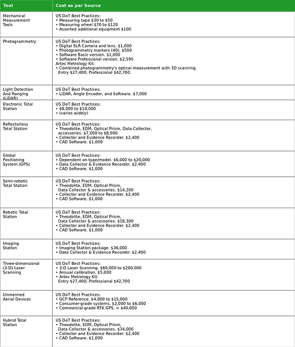
Costs per tool